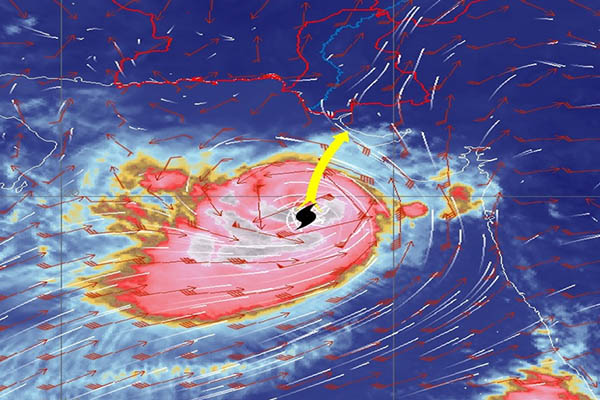
Satellite imagery from 10 a.m., June 12. Photo courtesy Tropical Cyclone Warning Center, Karachi
Cyclone Biparjoy, dubbed an extremely severe cyclonic storm, is currently about 600km south of Karachi, the Pakistan Meteorological Department (PMD) warned on Monday, stressing that it could hit landfall in Pakistan tomorrow (Tuesday), with its weather patterns to continue till June 17 (Saturday).
In an advisory, the PMD said that Biparjoy was currently 580km south of Thatta and 710km southeast of Ormara in Balochistan. “Maximum sustained surface winds are 160-180km/hour, with gusts of 200km/hour around the system center and sea conditions being phenomenal around the system center with maximum wave height of 35-40 feet,” it said, warning that favorable environmental conditions of a sea surface temperature of 30-31°C, low vertical wind shear and upper-level divergence were supporting the system’s severity.
Based on the current steering winds, said the PMD, Biparjoy would continue to track northward until June 14 before recurving northeastward and crossing between Keti Bandar in Sindh and the Indian Gujarat coast on June 15 as a “very severe cyclonic storm.”
Based on the current trajectory of the cyclone, forecast the national weather body, wind-dust/thunderstorm rain with some very heavy/extremely heavy falls and winds of 80-100km/hour were likely in Thatta, Sujawal, Badin, Tharparker, Mirpurkhas and Umerkot districts from June 13-17. It said dust/thunderstorm-rain with few heavy falls and winds of 60-80km/hour were likely in Karachi, Hyderabad, Tando Muhammad Khan, Tando Allayar, Shaheed Benazirabad and Sanghar districts from June 14-16.
Stressing that high-intensity winds could damage loose and vulnerable structures, including solar panels, the PDM urged authorities to remain alert and take corrective measures. It said a storm surge of 3-3.5 meters was expected at the landfall point around Keti Bandar, stressing this could inundate low-lying settlements. In this regard, the PMD advised fishermen against venturing to the open sea until June 17, emphasizing that conditions in the Arabian Sea conditions would likely be very rough this week.
As part of the measures to prepare for the cyclone, the Karachi administration has decided to evacuate areas along the coastline, including Baba Bhit, Mubarak Village, Ibrahim Hydri Village, the harbor, and other low-lying areas and villages. The plan calls for the evacuation of 10,000 people, announced Sindh Chief Minister Murad Ali Shah in a press conference on Sunday.
The Sindh Building Control Authority has also issued directions for the evacuation of “dangerous buildings,” including those with “weak glass panels” or under-construction scaffolding. It has further directed for the removal of construction machinery in the areas under threat.
Due to the threat posed by Biparjoy for parts of Balochistan, the Provincial Disaster Management Authority (PDMA) chief has said plans are in place to counter it, including declaring an emergency in hospitals and imposing a complete ban on visits to coastal areas. A ban has also been imposed on fishing, with fishermen advised against venturing into the open sea while rough conditions persist.
In Karachi, the Civil Aviation Authority has advised officials to ensure the safety of lightweight aircraft and other electrical equipment by taking precautionary measures such as either the mooring or re-parking of aircraft. It has further said goods near runways and tarmac area in Karachi should be moved to safer places.
“All departments in Sindh and Balochistan should be on high alert,” stressed Climate Change Minister Sherry Rehman, describing Biparjoy as “unpredictable” but of “high intensity.” She said panic would be counterproductive, but “caution and planning are better than being caught unawares.”
In a statement, the National Disaster Management Authority (NDMA) said its national emergency operations center was continuously monitoring and sharing information with all stakeholders and public through its website. It urged the public to avail the information and follow all official updates and warnings to protect themselves and their properties from any possible impacts of the cyclone.